Tim Berners- Lee has a 6 minute TED presentation on the year open data went worldwide.
Map and location services are top scenarios for mobile devices. Google and Microsoft have their maps. Nokia bought Navteq and MetaCarta. Apple bought PlaceBase. With all the companies creating services, volunteers using an open approach to collaborate can beat the proprietary services.
The MercuryNews reports on Open Street Maps.
Volunteers create new digital maps
By Mike Swift
Posted: 04/09/2010 09:08:55 PM PDT
Updated: 04/10/2010 01:36:26 PM PDT
Ron Perez hikes by a waterfall while a portable GPS device records his tracks as... (Jim Gensheimer)
When Brian "Beej" Hall first heard about an audacious volunteer effort to create an Internet map of every street and path in every city and village on the planet, he was hooked. At the time, the nascent effort had only a few American members, and the U.S. map was essentially a digital terra incognita.
Just a few years later, the Berkeley software engineer is editing digital maps so precise they include drinking fountains and benches in the Bay Area parks where he hikes, and the mapping community has swelled to more than 240,000 global members. The effort, OpenStreetMap, is a kind of grass-roots Wikipedia for maps that is transforming how map data is collected, shared and used — from the desktop to smartphones to car navigation.

The reporter makes the observation of how a nonprofit community can change the map business.
But increasingly, the nonprofit community collaboration model behind OpenStreetMap, which shares all the cartographic data in its maps for free, is also changing the business of mapping, just as Wikipedia changed the business of reference. More and more, the accuracy of searches on Google Maps or directions issued by your car's navigational device are based on data collected by volunteers like Hall and other members of OpenStreetMap's do-it-yourself army.
Part of the reason why OpenStreetMap is popular is the fact that the end users are creating the maps.
OpenStreetMap users say that because their data is collected by people who actually live in a place, it is more likely to be accurate.
"It's the people's map," said Paul Jarrett, director of mapping for CloudMade.
If you are interested in the use of OpenStreetMap in Haiti go here.
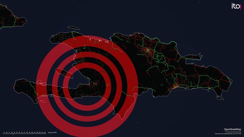
We chose to tell the story of 'OpenStreetMap - Project Haiti'.
We all followed the crisis that unfolded following the Haiti earthquake, many of us chose to donate money, a few were flown out and deployed as part of the relief effort. But what practical impact can many have without being there in Haiti itself? Well, during this crisis a remarkable story unfolded; of how people around the world could virtually collaborate and contribute to the on-the-ground operations.
With the little existing physical, political and social infrastructure now destroyed or damaged, the situation was especially challenging for aid agencies arriving on the ground. Where are the areas most in need of assistance, how do we get there, where are people trapped under buildings, which roads are blocked? This information is important to the rescue agencies immediately after the event, and to the longer rebuilding process. In many developing countries, there is a lack of good mapping data and particularly after a crisis, when up-to-date information is critical to managing events as they evolve.
Enter OpenStreetMap, the wiki map of the world, CrisisMappers and an impromptu community of volunteers who collaborated to produce the most authoritative map of Haiti in existence. Within hours of the event people were adding detail to the map, but on January 14th high resolution sattelite imagery of Haiti was made freely available and the Crisis Mapping community were able to trace roads, damaged buildings, and enter camps of displaced people into OpenStreetMap. This is the story of OpenStreetMap - Project Haiti:
There are many who think the Open Source Data Center Initiative will not work. There are a lot of people who thought OpenStreetMaps wouldn't work too.